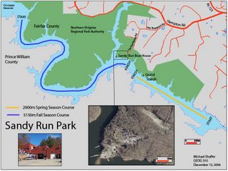
This is my final project map of Occoquan Reservoir and Sandy Run Regional Park. The park is used for rowing activities for high schools, colleges and other clubs and organizations. I mapped both the Spring and Fall race courses.
I used a variety of data sources for the project. The first data source was the Fairfax County GIS and Mapping Department. This is where I got the shape file for the park boundaries, the reservoir boundaries and the roads. I could of used Illustrator but I figured it would be more accurate just to get these from shape files.
Fairfax GIS and Mapping Department
Another website I used was the Occoquan Boat Club homepage, where they have information about the races.
Occoquan Boat Club
I used Google Earth to get a high resolution image of the inset area.
Google Earth
A good site to find images of the races held at Occoquan is row2k.org.
Row2k.org
Sandy Run Regional Park is run by the Northern Virginia Regional Park Authority. Their homepage is:
NVRPA
